Need a Topographical Survey?
Topographical survey plan may be a ‘general-use’ survey plan but it is not an all-purpose survey plan. It is a detailed representation of a plot of land showing visible features such as building lines, drains, walls, fences, trees, manholes and includes their elevations.
Where required, the boundaries are also included and land lot information are also incorporated. However, these boundaries should be done in the prevailing SVY21 datum in compliance with Singapore Land Authority’s (SLA) directives.
Property owners, developers, architects, engineers, builders, property managers and planners may call for topographical surveys for:
- Intended improvement or redevelopment
- Verification of a property purchased
- Design development
- Submission to authorities
- Construction activities
- Verification of as-built features
- Estate management & planning

What is not included?
Topographical survey does not cover the interiors of a building. If required, these are floor plans and elevations executed under building or measured drawing surveys that can be linked to the topographical survey. Such surveys are usually required for old properties where existing building plans are outdated, not authoritative or not available.
Is topographical survey regulated?
Topographical surveys are under the statutory purview of the Land Surveyors Board (LSB) and the practice being governed by LSB Directives while the boundaries, if involved, are to comply with SLA’s directives. The topographical survey statutorily has to be conducted under a Registered Surveyor who has a valid practising licence.
The topographical survey is to be done in SVY21 datum, our prevailing cadastral grid reference. Where a land lot is under the disused ‘Cassini’, the boundaries must be verified by a Registered Surveyor and the boundary coordinates being refined by SLA. The previous practice of ‘Cassini’ boundary datum is non-compliant and consequentially the survey data obtained therefrom cannot be relied on.
The SVY21 datum is also the default datum adopted by government authorities as the common datum to ensure all survey data are in the same reference system. These authorities usually will specify the topographical survey plan to be certified by a Registered Surveyor.
The elevation (level) of any surveyed point is to be based on the Singapore Height Datum (SHD) which had replaced the Mean Sea Level (MSL). The level reference has to be obtained from a Vertical Control Point (VCP) managed by SLA. The VCP must be proven to be stable before use.
The method and accuracy of a topographical survey, if not specified in a contract, shall comply with the LSB’s directives.
Details in a topographical survey
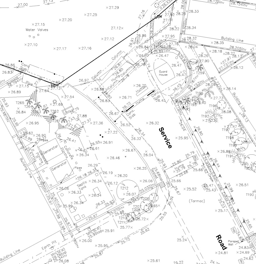
Typical features recorded in a topographical survey are:
- Building lines
- Drains
- Driveways
- Inspection chambers & sewer manholes
- Perimeter features (wall, fence)
- Trees
- Spot levels
- All other visible material features on the ground
Other information that may be relevant in the topographical survey plan are:
- Land lot boundaries
- Building setbacks from the boundaries
- Road Reserve Line, Drainage Reserve Line, Railway Protection Lines
- Utilities lines (if priorly detected by a licenced person)
Information that can be derived from the survey data and included into the topographical survey plan are:
- Contour lines – if the grounds are of varying elevations
- Cross sections of the surveyed area
Drawing Compliances
The drawing of the topographical survey plan should comply with Code of Practice for Construction Computer-aided Design – CP83. It provides the concept, format and codes used in construction documents to facilitate common understanding and interpretation of information in drawings by different users of the building industry and easy and efficient exchange of information.
What can go wrong?
While a topographical survey plan can look ‘perfect’, it may be incomplete if certain features were not surveyed. A water valve may be obscured by scrubs. A manhole could be covered over by pots of plants. The invert level of an inspection chamber may be omitted because the cover was ‘jammed’.
Wrong measurements may occur with survey instrument pointing to a wrong point when making a non-contact measurement using laser. The mistake can also be a measurement made to the edge of a tree but subsequently plotted as the centre of the tree (which is positionally wrong).
Identification of trees by surveyors are made ‘to the best of their knowledge’. Essentially surveyors are not experts on trees and the tree species can be wrongly identified. If correct identification of trees is important, clients should engage an arborist to provide the correct identification of trees.
Generally old topographical survey plans are not be re-used, and if re-used, they should be verified by the Registered Surveyor first before adoption. Features depicted in the old topographical survey plan may have changed. The survey stations and benchmarks depicted in the plan or survey records may have moved over time. Or a feature shown in the old plan may have been demolished. A topographical survey should always be a fresh survey.
Do I need the final product in 3D?

For specialised applications such as 3D models or Building Information Management (BIM), 3D data, rather than a 2D topographical survey plans, are required.
Although the topographical information is shown on a 2D plan (plus levels annotated), the features are actually surveyed in 3D with survey instruments. Where the 3D is important, such as underground utility mapping, the 3D points are used to produce digital 3D models. 3D terrain models can also be produced.
The practice of 3D topographical survey should comply with the guidelines published by SLA – “Standard and Specifications for 3D Topographic Surveying (Mapping) in Singapore”.
Collection of the 3D data can be by conventional total stations or laser scanner. The resulting 3D information can also be referenced to SVY21 datum and SHD. Only the Registered Surveyor can certify the data to that effect.
Can a topographical survey be used to ascertain encroachment?
In a topographical survey, boundaries are to be determined accurately in compliance to SLA’s directives – but the features are not surveyed to the same quality. A topographical survey plan consequentially cannot be used for encroachment issues because the accuracy of the measurements falls short of that required for boundary works. A separate encroachment survey will be necessary for such purpose. Any encroachment depicted in a topographical survey is, at best, only indicative and it cannot be not authoritative on the matter.
Conclusion
In view of the statutory requirements and specifications and potential pitfalls, a client needing a topographical survey should protect his interest by exercising the following:
- Engage a Registered Surveyor
- The survey is conducted in SVY21 datum & SHD – compliance to SLA’s and LSB’s directives
- Verification and refinement of boundaries if they are in the disused system
- Drawing to adequate details and in compliance with CP83.
Need a topographical survey? Contact us here
